XGRIDSDocs
  • 简体中文
  • English
  • 繁體中文
  • 日本語
  • Deutsch
  • Español
  • Italiano
  • 简体中文
  • English
  • 繁體中文
  • 日本語
  • Deutsch
  • Español
  • Italiano
  • PortalCam

    • Product Overview
    • Basic Operation
    • Using the LCC Scan App
    • Maintenance and Care
    • FAQ
  • Lixel K Series

    • Lixel K1

      • Product Overview
      • Basic Operation
      • Device Activation and Connection
      • Scanning Workflow
      • Acquire Point Cloud Data with Absolute Coordinate
      • Map Fusion
      • Route Planning Suggestions for Typical Scenes
      • Precautions
      • FAQ
    • Lixel K2

      • Product Overview
      • Basic Operation
      • Device Activation and Connection
      • Scanning Workflow
      • Acquire Point Cloud Data with Absolute Coordinate
      • Map Fusion
      • Route Planning Suggestions for Typical Scenes
      • Precautions
      • FAQ
  • Lixel L Series

    • Lixel L2 Pro

      • Product Overview
      • Basic Operation
      • Device Activation and Connection
      • Scanning Workflow
      • Acquire Point Cloud Data with Absolute Coordinate
      • Measure Point
      • Appendix
      • FAQ
  • Lixel Studio

    • Version and Copyright
    • Installation and Activation
    • Software Interface
    • File Operations
    • Project Processing
    • Tools
    • 2D Drawing
    • Applications
    • Settings
    • Device Connection
    • FAQ
  • Lixel CyberColor

    • LCC Studio

      • Getting Started
      • Version and Updates
      • Download and Installation
      • Interface Overview and Navigation
      • Pre-Reconstruction Work
      • Model Reconstruction
      • Single Model Reconstruction
      • Map Fusion
      • Aerial-Ground Map Fusion
      • Aerial Reconstruction
      • My Models
      • Other Features
      • Settings and Account
      • Video Reconstruction
      • FAQ
    • LCC Scene Editor

      • Version & Updates
      • Account & Login
      • Product Overview & Home
      • Editor Interface
      • Scene Navigation Modes
      • File
      • Settings
      • Edit Operations
      • Window
      • Global Toolbar
      • Assets & Properties
      • Left Toolbar
      • Viewpoints
      • Portal
      • Skybox
      • Annotations
      • Measurement
      • Flythrough
      • Scene Report
      • 3D Layout
      • Preview Mode (Viewer)
      • Help
      • FAQ
      • Spawn Point
    • LCC Model Editor

      • Version and Updates
      • User Guide
      • Overview and Interface
      • File Operations
      • Selectors
      • Editing Models
      • Measurement
      • Color Grading
      • Asset Management
      • Settings and Help
      • FAQ
    • 04-capture-guide

      • Overview
      • Capture Devices Overview
      • General Capture Principles
      • Indoor Scene Capture
      • Outdoor Scene Capture
      • Large-Scale Capture (Map Fusion)
      • Aerial-Ground Map Fusion Capture
      • Object Capture
      • People Capture
      • Video Reconstruction Capture
      • HD Enhancement
      • Control Points (Lixel P1)
      • FAQ and Troubleshooting
    • Version History

Outdoor Scene Capture

Applicable devices: Lixel K2 (recommended), Lixel L2 Pro

Time Selection

TimeSuitabilityNotes
Overcast, all day⭐⭐⭐ BestEven lighting, no harsh shadows
Sunny morning/evening⭐⭐ GoodLonger but softer shadows
Sunny noon⭐ FairShort but harsh shadows, excessive contrast
Rainy/night❌ Not recommendedInsufficient light, ground reflections

Capture Paths

Building Facade

  1. Walk a loop around the building perimeter (3–5 m from the building), shooting the main body at eye level
  2. Walk another loop (1–2 m from the building), shooting high-up details at an upward angle
  3. Add extra multi-angle coverage of key areas (entrances, signs, distinctive structures)
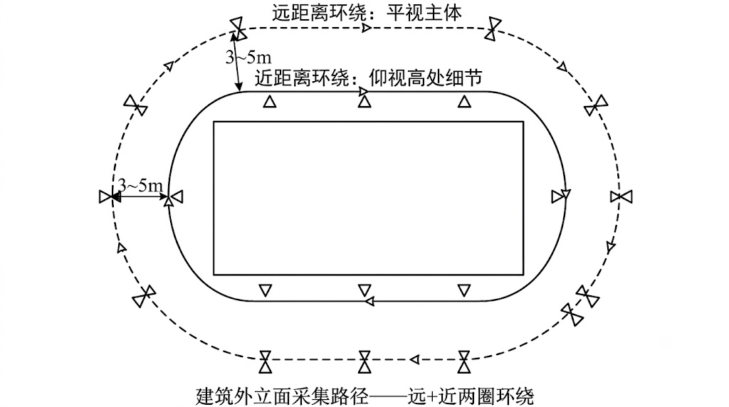
Building Facade Path

Building facade capture path (far + near double loop)

Streets/Roads

  1. Walk along one side of the road, shooting the buildings on the opposite side
  2. On the return, walk along the other side, shooting the buildings on this side
  3. Cover intersections/junctions from multiple angles

Outdoor Considerations

  • Pedestrians/vehicles: Choose times with fewer people when possible; moving objects produce artifacts
  • Vegetation: Leaves swaying in the wind produce blur; light-breeze weather is best
  • Sky: Sky regions have no texture and limited reconstruction results, which is normal
  • RTK positioning: The K2 supports RTK; enabling it for outdoor capture is recommended to obtain precise geographic coordinates
  • Shadow consistency: Changes in the sun's position during capture cause shadows to move; try to finish within 30 minutes
  • Lighting consistency: If multi-segment stitching is needed, all data segments should be captured within 2 hours to avoid drastic morning/evening lighting changes

Outdoor Capture Checklist

  • [ ] Suitable weather conditions (overcast or soft lighting)
  • [ ] Low pedestrian/vehicle traffic
  • [ ] RTK enabled with good signal (when absolute coordinates are required)
  • [ ] All faces of the building covered
  • [ ] Both ground and high-up angles covered
Prev
Indoor Scene Capture
Next
Large-Scale Capture (Map Fusion)