
Aerial-Ground Map Fusion Capture
Applicable devices: Recommended Lixel L2 Pro + DJI drone; supports Lixel K1, Lixel K2, Lixel P1 + drone
What Is Aerial-Ground Map Fusion
Aerial-ground map fusion achieves multi-view, multi-scale integrated modeling by fusing aerial imagery from a drone with ground data captured by XGRIDS handheld devices. It is suitable for complete modeling of complex terrain such as large sites, building clusters, and scenic areas.
Prerequisites
- The ground portion of aerial-ground map fusion supports stitching multiple segments of ground capture data, with the same capture requirements as map fusion
- For drones with multi-focal-length cameras, use the same focal length throughout a single reconstruction
P Series Devices (Lixel P1)
- P series devices use aerial-ground fusion control points to align ground and aerial data
- The drone does not need RTK (turn off the drone RTK data toggle); combined with aerial-ground fusion control points, this yields good results
- At each drone takeoff/landing point, mark an aerial-ground fusion point and upload the aerial photos and takeoff/landing point photo folder for that position
- If aerial photos are uploaded directly without marking an aerial-ground fusion point at the drone takeoff/landing point during capture, there is a chance of reduced fusion quality or reconstruction failure
L Series Devices (Lixel L2 Pro)
- L series devices use the device's built-in RTK positioning for absolute coordinates
- Both ground and drone must have RTK enabled and use the same coordinate system (WGS84 or CGCS2000)
- The capture scene needs good RTK signal
- Not recommended: L series RTK + drone without RTK combination, which may cause reconstruction failure or model layer separation
Recommended Device Combinations
| Ground Data | Drone Data | Recommendation | Description |
|---|---|---|---|
| L series RTK | Drone RTK | ⭐⭐⭐ | Highest accuracy, recommended |
| P series aerial-ground fusion control points | Drone RTK | ⭐⭐⭐ | Recommended |
| P series aerial-ground fusion control points | Drone without RTK | ⭐⭐⭐ | Recommended, supports consumer-grade drones |
| L series RTK | Drone without RTK | ⚠️ | Not recommended, may cause reconstruction failure or layer separation |
Data Composition
Aerial-ground map fusion data must include 2 parts of imagery:
| Data Type | Capture Method | Description |
|---|---|---|
| Aerial portion | Drone aerial photography | Top-down scene data |
| Takeoff/landing portion | Drone takeoff/landing capture | Linking data between aerial and ground views (key) |
Recommended Drone Models
| Recommended | Acceptable | Not Recommended |
|---|---|---|
| Zenmuse P1 | DJI M3E / DJI M4E / DJI P4R | DJI M3T / FC3582 |
Aerial Portion
The aerial portion is basically captured according to normal oblique photography requirements.
| Item | Recommendation |
|---|---|
| Flight mode | Recommended grid flight to ensure full coverage |
| Overlap rate | ≥ 85% |
| Flight altitude | Flying at the lowest safe altitude allowed gives the best results; except for special restrictions, not recommended above 50 m |
| Single/multi-layer | Simple small/medium scenes: fly one layer at the lowest safe altitude; complex large scenes: fly an additional 1-2 layers above the lowest layer |
| Multi-layer height difference | The height difference between adjacent layers should not exceed 2x |
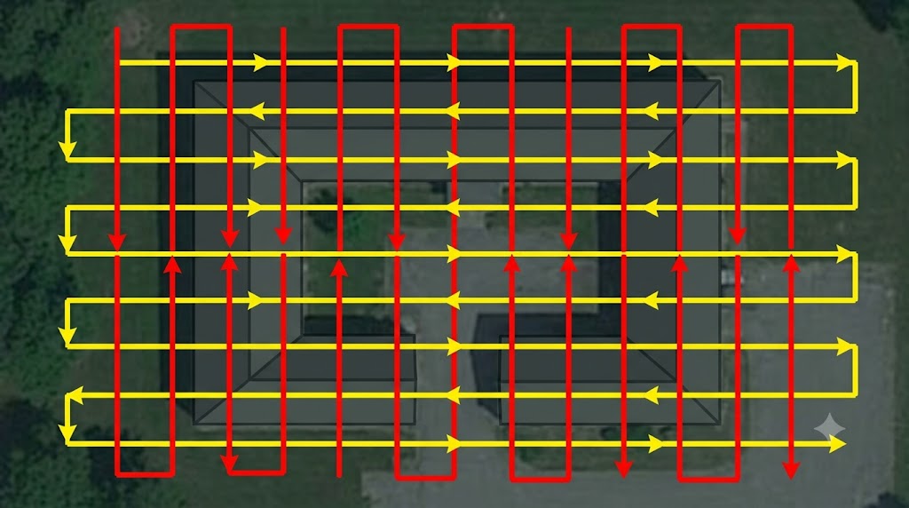
Drone grid flight path planning
Building Facade Capture
In addition to the rooftop grid flight, building facades (exteriors) also need dedicated coverage.
Orbit Flight
The drone flies around the building perimeter to cover all facades:
| Item | Recommendation |
|---|---|
| Flight distance | 3-5 m from the building facade |
| Flight altitude | 1/2 to 2/3 of the building height (to ensure top-to-bottom coverage) |
| Lens orientation | Always facing the building exterior wall |
| Flight speed | ≤ 5 m/s, steady and uniform |
| Coverage requirement | All four sides of the building must be orbited; slow down at corners for multi-angle coverage |
| Multi-layer orbit | Tall buildings can be orbited at 2-3 different heights |
Problem solved by orbit capture: Grid flight only covers rooftop and ground top-down views; building facades (windows, wall details, entrances) need to be supplemented through orbiting.
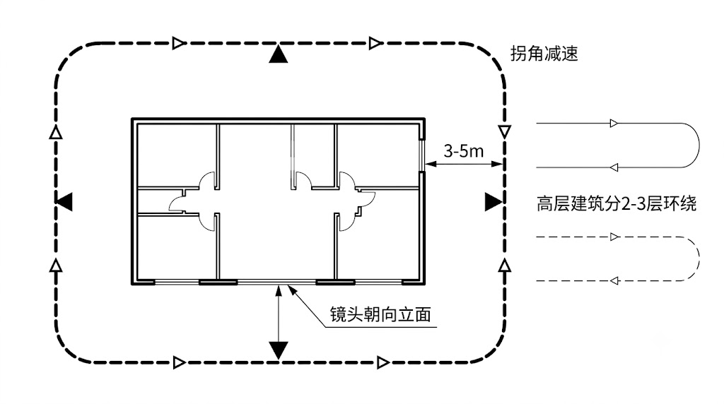
Building facade orbit capture path (top-down view)
Aerial-Ground Data Linking
For aerial and ground data to fuse successfully, the key is that the two datasets have an overlapping linking region:
- The drone should power on and take off above a route already captured by the ground device
- Before takeoff, shoot at eye level at ground height (about 1.5 m) to ensure viewpoint overlap with the ground scan trajectory
- Then ascend vertically into the aerial photography altitude
Simply put: drone takeoff point = on the route the ground device walked, so the two datasets naturally have a "handshake" link.
Ground Scan Requirements
- Use XGRIDS handheld devices to scan following the normal outdoor capture workflow
- Focus on covering the building base, ground textures, entrances, etc.
- Building facades need multi-height coverage: referencing the indoor "three-pass method" approach, the ground device should also cover building facades from three angles — low (ground details), eye-level (main body), and high (upper structures)
- Ensure the scan path passes near the drone takeoff/landing point
Takeoff/Landing Portion
The takeoff/landing portion links the aerial view with the ground view and is the key factor affecting fusion quality.
Takeoff/Landing Quantity and Distribution
- Arrange at least 3-4 takeoff/landing captures per scene, distributed across the capture scene
- For larger scenes: ensure at least 1 takeoff/landing capture every 50-100 m
Takeoff/Landing Capture Requirements
Each takeoff/landing must provide continuous imagery from about 1.5 m above the ground to the aerial flight altitude, and satisfy:
- Ground eye-level shooting: The position and viewpoint have sufficient overlap with the ground device's capture trajectory. Since drone FOV is usually small, while prioritizing viewpoint coverage, the drone may move somewhat away from the subject at the takeoff/landing position for best coverage, but should not exceed 1.5x the ground capture distance
- Aerial top-down shooting: The position and viewpoint have sufficient overlap with the aerial imagery
- Smooth transition: The camera position and angle from ground to aerial views transition smoothly, with adjacent image overlap rate ≥ 85%
- Highest point of takeoff/landing: The highest point of each takeoff/landing capture should exceed the flight altitude of the grid oblique photography route by about 5 meters
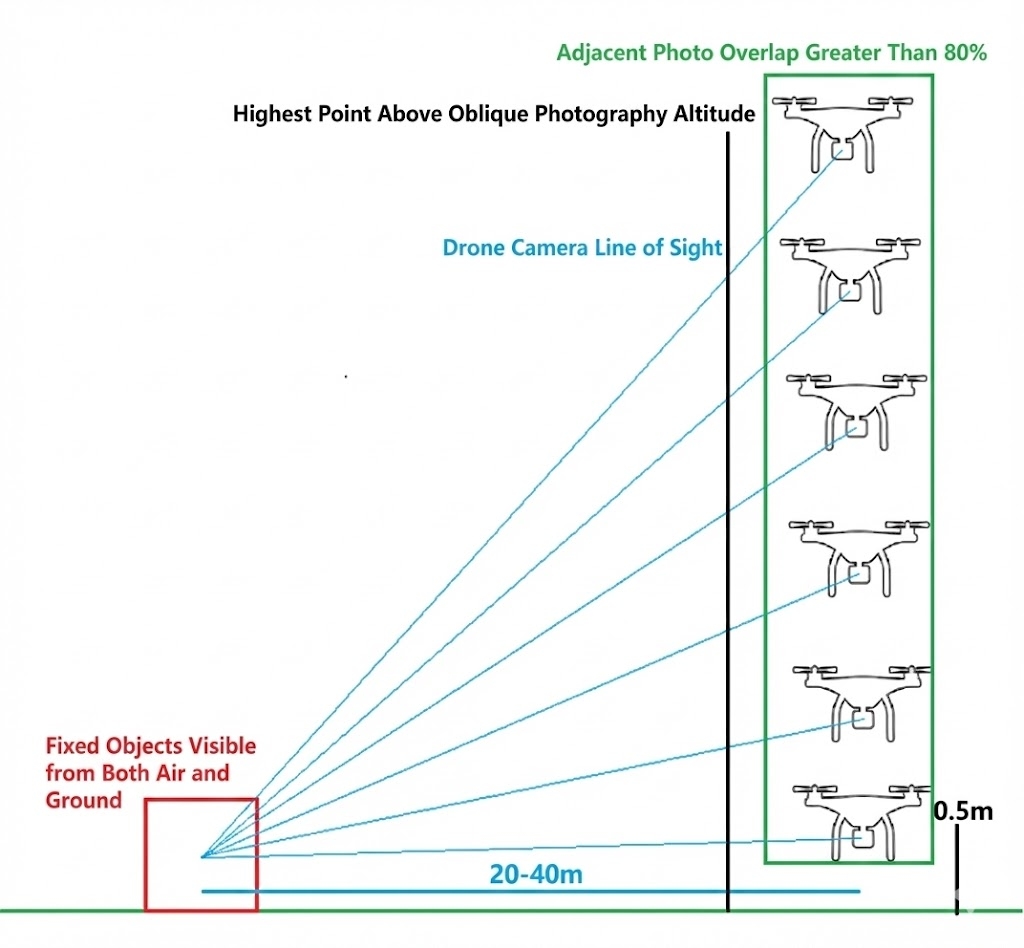
Takeoff/landing schematic: continuous capture from ground eye-level to aerial flight altitude
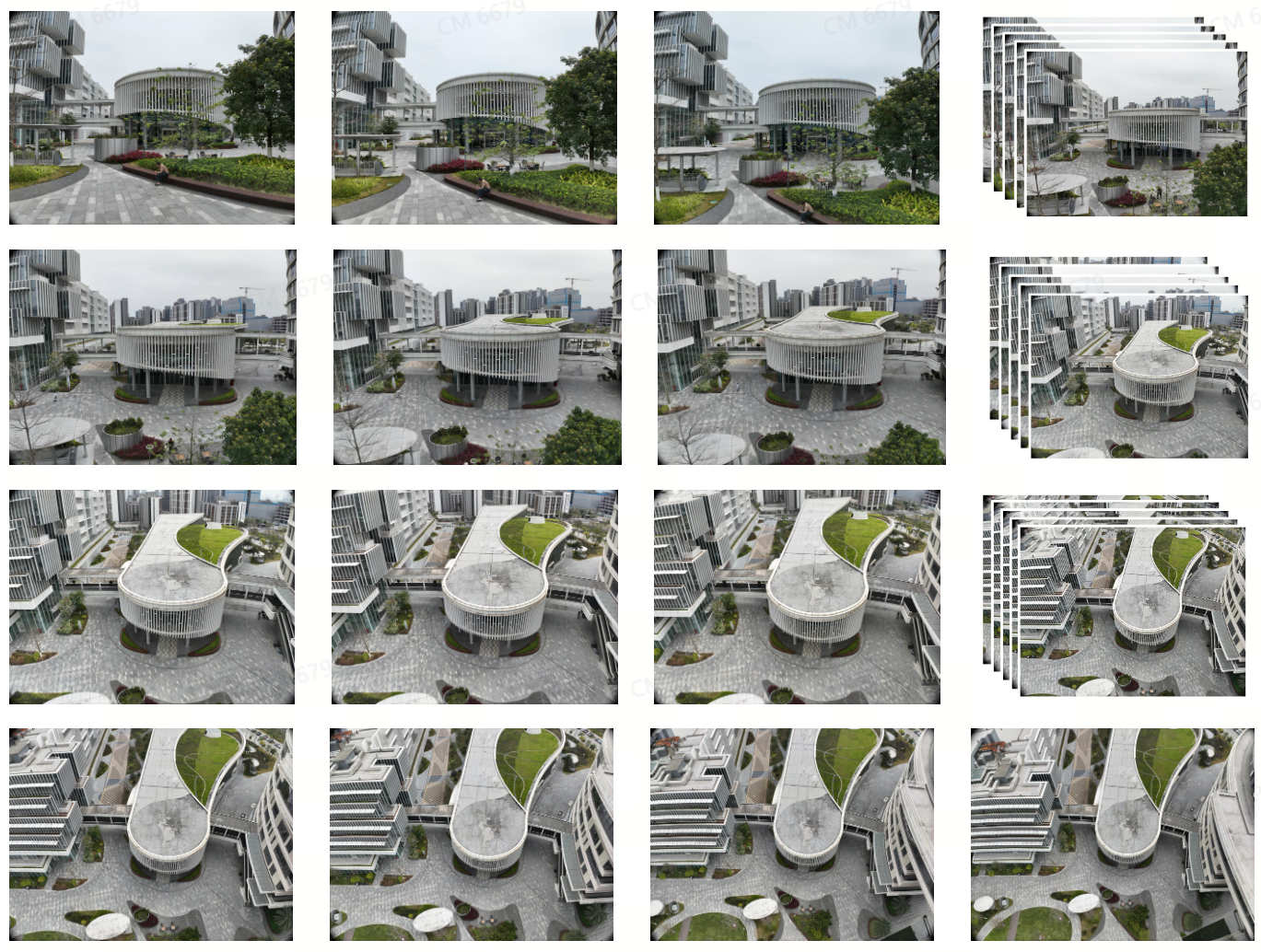
Takeoff/landing capture: smooth transition from ground eye-level to aerial top-down
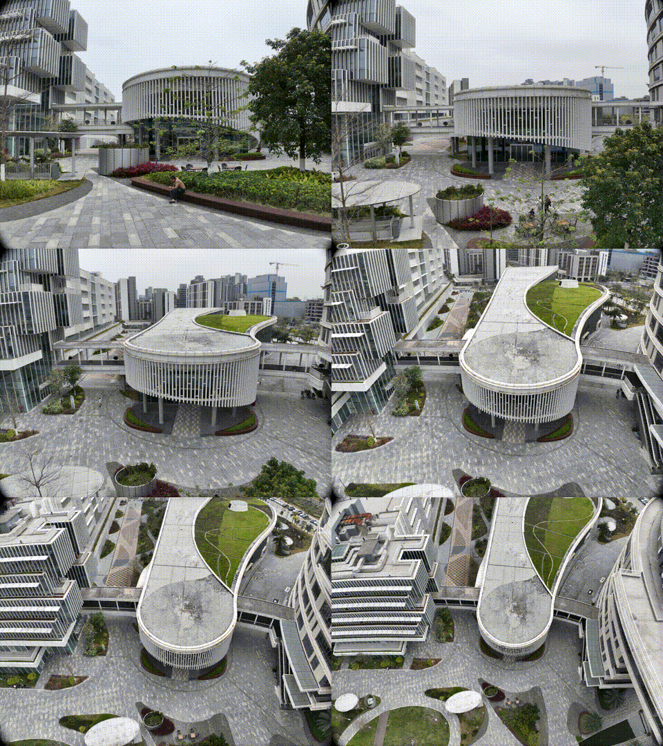
Takeoff/landing process animation
Takeoff/Landing Point Selection Principles
| ✅ Correct | ❌ Incorrect |
|---|---|
| Relatively open ahead, no line-of-sight obstruction within 10 m | Close to plain-colored walls or reflective surfaces |
| Facing distinctive buildings or facades | Close to trees or repetitive structures |
| Multiple takeoffs/landings face the same subject in the scene | Facing a non-distinctive background |
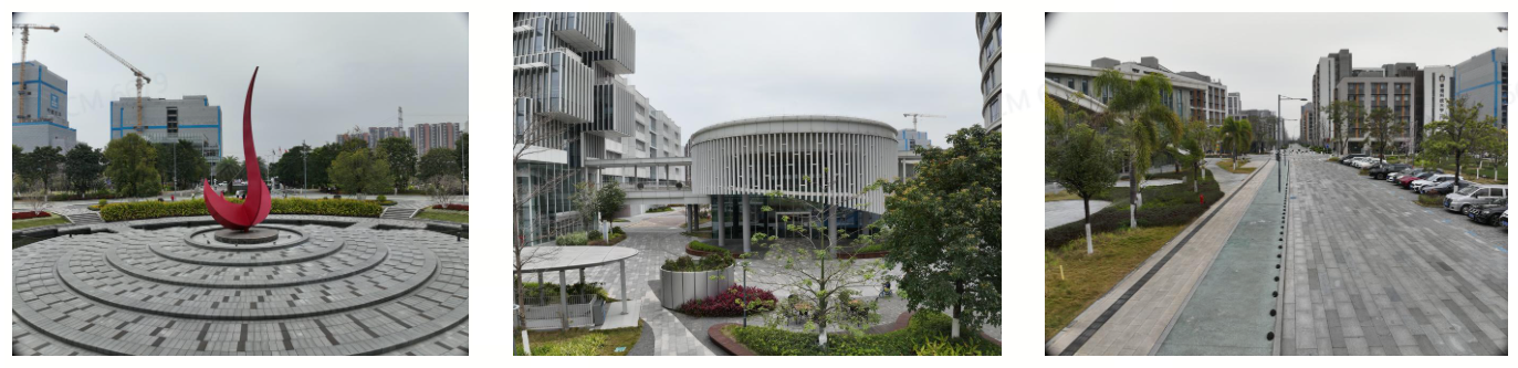
Correct example: facing a distinctive building facade
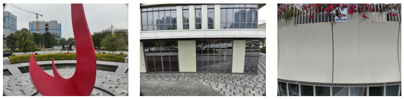
Incorrect example: close to plain color/reflection/trees/repetitive structures
Aerial Reconstruction
Aerial reconstruction is the same as the aerial portion of aerial-ground map fusion, basically captured according to normal oblique photography requirements. It is suitable for scenes that do not need ground data and use only drone aerial photography for 3DGS reconstruction.
The capture requirements are exactly the same as the "Aerial Portion" above:
- Recommended grid flight, overlap rate ≥ 85%
- Fly at the lowest safe altitude allowed (≤ 50 m)
- Complex large scenes can fly an additional 1-2 layers above the lowest layer (adjacent layer height difference not exceeding 2x)
- Flight speed ≤ 5 m/s
- Use a single focal length
With RTK
- The drone must capture with RTK enabled (WGS84 or CGCS2000)
- The reconstructed model will contain absolute coordinate information and can be exported to GIS platforms
Without RTK (v2.2.0)
Starting from v2.2.0, aerial reconstruction supports drones without RTK:
- Turn off the drone RTK data toggle (or the drone itself does not have RTK capability)
- Higher overlap is required: forward overlap ≥ 80%, side overlap ≥ 70% recommended
- Grid or orbit flight paths are recommended to ensure sufficient coverage from all angles
- The model will not contain absolute coordinate information and cannot be exported to GIS platforms for geographic positioning
- Suitable for quick modeling scenarios that do not require absolute coordinates (e.g., construction progress tracking, visualization)
Difference between aerial reconstruction and aerial-ground map fusion: aerial reconstruction has only aerial data and does not need ground scanning or takeoff/landing linking. It is suitable for rooftops, large plazas, farmland, and other scenes that do not need ground details.
Reconstruction Area and GSD Empirical Metrics
Below are operational reference data for the M4E model at different survey areas and GSD values:
| Survey Area | Oblique GSD (cm) | Flight Altitude (m) | Operation Time | Number of Drone Photos |
|---|---|---|---|---|
| 10,000 m² | 0.5 | 12 | 2 h 8 min | 11139 |
| 10,000 m² | 1 | 26 | 28 min | 2390 |
| 10,000 m² | 2 | 53 | 9 min | 633 |
| 10,000 m² | 3 | 79 | 6 min | 284 |
| 50,000 m² | 0.5 | 12 | 9 h 20 min | 53316 |
| 50,000 m² | 1 | 26 | 1 h 55 min | 11399 |
| 50,000 m² | 2 | 53 | 32 min | 2847 |
| 50,000 m² | 3 | 79 | 17 min | 1279 |
| 100,000 m² | 0.5 | 12 | 18 h 13 min | 105308 |
| 100,000 m² | 1 | 26 | 3 h 43 min | 22448 |
| 100,000 m² | 2 | 53 | 1 h 1 min | 5563 |
| 100,000 m² | 3 | 79 | 29 min | 2475 |
The smaller the GSD (the lower the flight), the richer the detail, but operation time and data volume grow exponentially. Choose an appropriate GSD based on scene accuracy requirements; 1-2 cm typically meets most aerial-ground fusion scenarios.
Aerial-Ground Map Fusion Checklist
- [ ] Confirm device combination (refer to the Recommended Device Combinations table)
- [ ] L series: both ground and drone have RTK enabled and set to the same coordinate system
- [ ] P series: aerial-ground fusion control points marked at takeoff/landing points
- [ ] RTK mode: 80%+ of drone photos carry RTK data
- [ ] Drone uses a single focal length
- [ ] Aerial portion: grid flight, overlap rate ≥ 85%
- [ ] Aerial portion: fly at the lowest safe altitude (≤ 50 m)
- [ ] Takeoff/landing captures: ≥ 3-4, distributed (one every 50-100 m for large scenes)
- [ ] Takeoff/landing captures: ground eye-level → aerial top-down smooth transition, overlap ≥ 85%
- [ ] Takeoff/landing points: 10 m clear ahead, facing distinctive buildings
- [ ] Ground scan data complete (same capture requirements as map fusion)
- [ ] All data captured close in time (consistent lighting)