XGRIDSDocs
  • 简体中文
  • English
  • 繁體中文
  • 日本語
  • Deutsch
  • Español
  • Italiano
  • 简体中文
  • English
  • 繁體中文
  • 日本語
  • Deutsch
  • Español
  • Italiano
  • PortalCam

    • Product Overview
    • Basic Operation
    • Using the LCC Scan App
    • Maintenance and Care
    • FAQ
  • Lixel K Series

    • Lixel K1

      • Product Overview
      • Basic Operation
      • Device Activation and Connection
      • Scanning Workflow
      • Acquire Point Cloud Data with Absolute Coordinate
      • Map Fusion
      • Route Planning Suggestions for Typical Scenes
      • Precautions
      • FAQ
    • Lixel K2

      • Product Overview
      • Basic Operation
      • Device Activation and Connection
      • Scanning Workflow
      • Acquire Point Cloud Data with Absolute Coordinate
      • Map Fusion
      • Route Planning Suggestions for Typical Scenes
      • Precautions
      • FAQ
  • Lixel L Series

    • Lixel L2 Pro

      • Product Overview
      • Basic Operation
      • Device Activation and Connection
      • Scanning Workflow
      • Acquire Point Cloud Data with Absolute Coordinate
      • Measure Point
      • Appendix
      • FAQ
  • Lixel Studio

    • Version and Copyright
    • Installation and Activation
    • Software Interface
    • File Operations
    • Project Processing
    • Tools
    • 2D Drawing
    • Applications
    • Settings
    • Device Connection
    • FAQ
  • Lixel CyberColor

    • LCC Studio

      • Getting Started
      • Version and Updates
      • Download and Installation
      • Interface Overview and Navigation
      • Before Reconstruction
      • Model Reconstruction
      • Single Model Reconstruction
      • Map Fusion
      • Aerial-Ground Fusion
      • Aerial Reconstruction
      • My Models
      • Other Features
      • Settings and Account
      • Converter
      • Video Reconstruction
      • FAQ
    • LCC Scene Editor

      • Version & Updates
      • Account & Login
      • Product Overview & Home
      • Editor Interface
      • Scene Navigation Modes
      • File
      • Settings
      • Edit Operations
      • Window
      • Global Toolbar
      • Assets & Properties
      • Left Toolbar
      • Viewpoints
      • Portal
      • Skybox
      • Annotations
      • Measurement
      • Flythrough
      • Scene Report
      • 3D Layout
      • Mini-Map
      • Preview Mode (Viewer)
      • Help
      • FAQ
      • Spawn Point
    • LCC Model Editor

      • Version and Updates
      • User Guide
      • Overview and Interface
      • File Operations
      • Selectors
      • Editing Models
      • Measurement
      • Color Grading
      • Asset Management
      • Settings and Help
      • FAQ
    • Capture Guide

      • Overview
      • Capture Devices Overview
      • General Capture Principles
      • Indoor Scene Capture
      • Outdoor Scene Capture
      • Large-Scale Capture (Map Fusion)
      • Aerial-Ground Map Fusion Capture
      • Object Capture
      • People Capture
      • Video Reconstruction Capture
      • HD Enhancement
      • Control Points (Lixel P1)
      • FAQ and Troubleshooting
    • Version History

Mini-Map

The mini-map helps you quickly view your current position and viewing direction, making it easier to locate yourself and navigate in the 3D scene.
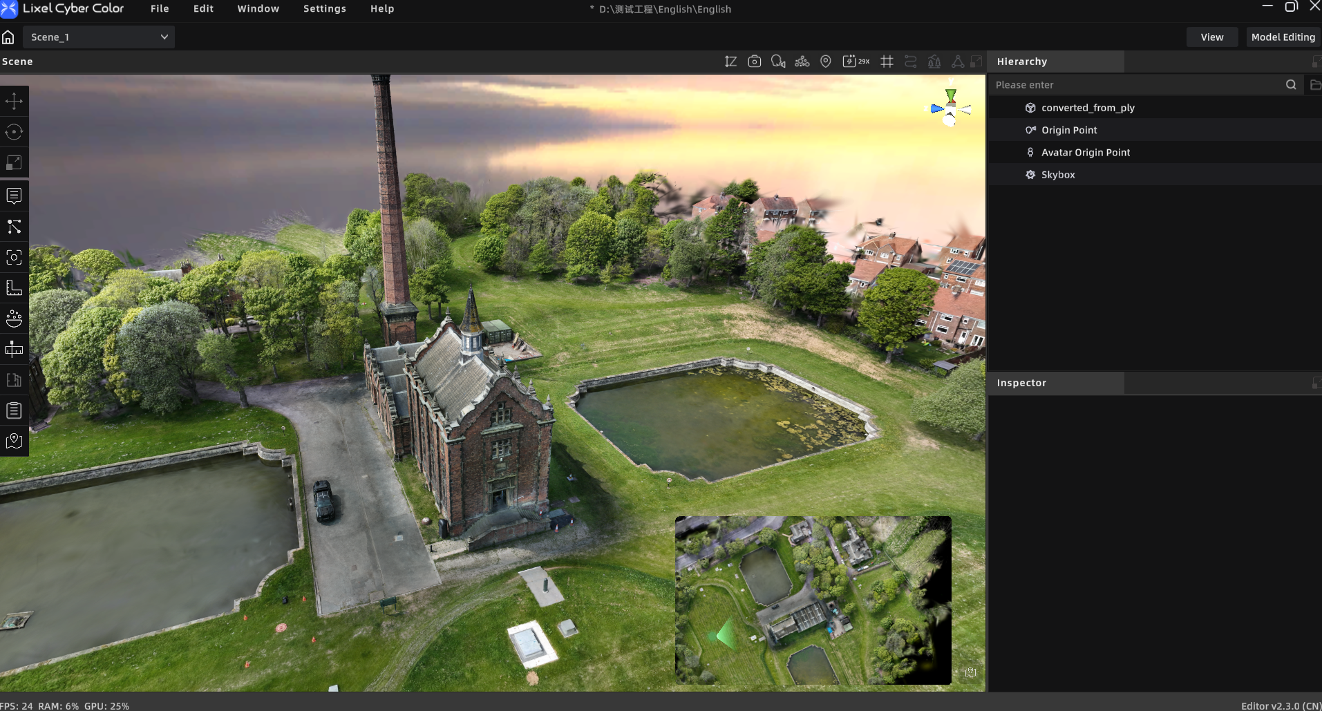
Mini-Map

Show or Hide the Mini-Map

The mini-map is generated automatically when you enter a scene. Click the Mini-Map toggle to show or hide the mini-map window. The mini-map is available in Edit Mode, Preview Mode, and Web Viewer.

The system selects a map based on the scene data:

  • If the scene does not contain 3D Layout data, a top-down view of the full scene is displayed by default.
  • If the scene contains 3D Layout data, the floor plan is displayed by default.

Switch Map Modes

When a scene contains 3D Layout data, you can switch between Floor Plan and Scene Overview modes. If the scene does not contain 3D Layout data, only the scene overview is available.

The first switch to Scene Overview mode may take a moment while the map is generated. Switching modes does not delete any saved maps or settings.

Edit the Scene Overview

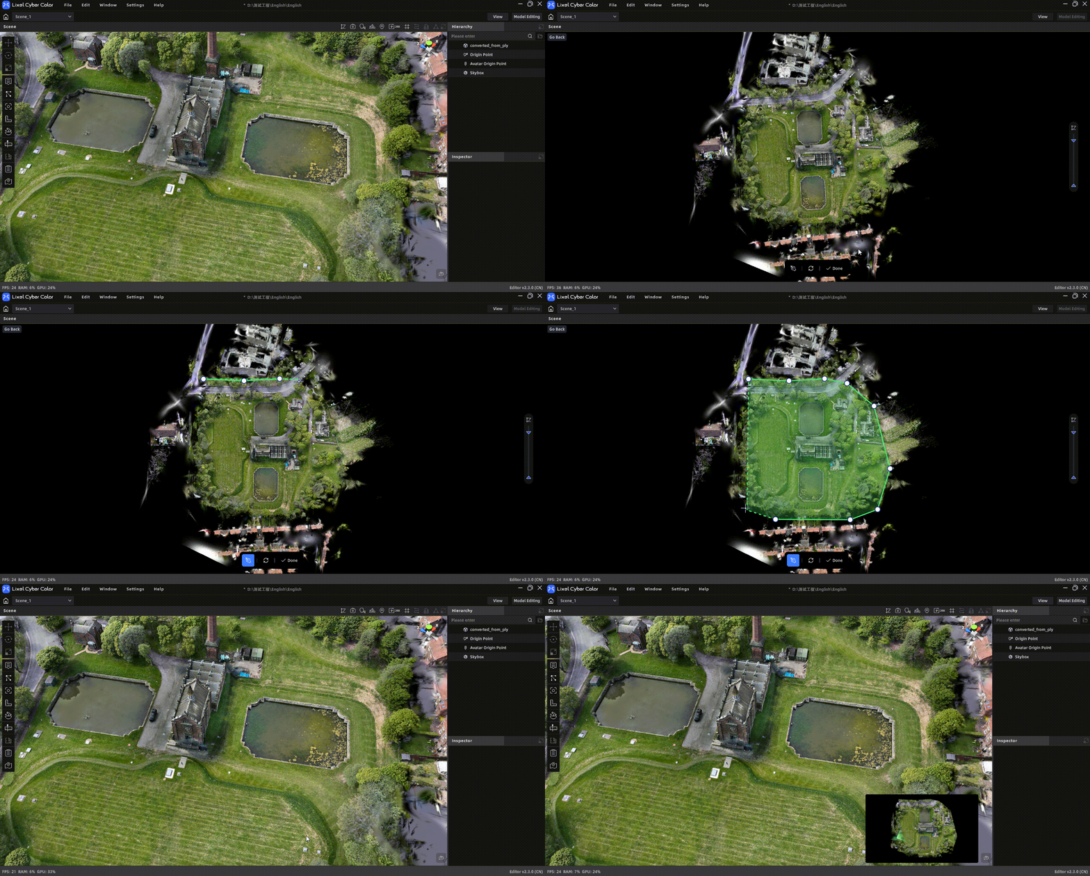
Click Mini-Map Tool to open the map editor.

  1. Adjust orientation: Rotate the scene to place the desired direction at the top of the mini-map. Click Reset to restore the default orientation.
  2. Filter by height: Adjust the height range to hide lower content that you do not want to show on the mini-map.
  3. Crop the map: Select the polygon crop tool, click to add points, and close the polygon. Only the content inside the polygon is retained.
  4. Preview the result: Check the map orientation, height filter, and crop area.
  5. Save the map: Click Save and Update Mini-Map and wait for the update to finish.

To restore the full map, clear the crop area. Height filtering and cropping affect only the mini-map display and do not modify the original scene.
Update the Floor Plan Map

Open the 3D Layout module, make your changes, and save the floor plan. The mini-map updates automatically; you do not need to generate it again.

Navigate with the Mini-Map

The mini-map displays the current camera position and viewing direction and updates automatically as you move through the 3D scene.

ActionResult
Move in the 3D sceneThe mini-map automatically follows your current position
Rotate the view in the 3D sceneThe direction indicator on the mini-map rotates accordingly
Scroll the mouse wheelZoom the mini-map in or out without changing your position in the 3D scene
Drag an empty area of the mapPan the mini-map without changing your position in the 3D scene
Drag the camera iconMove the 3D scene to the corresponding position
Drag the direction indicatorAdjust the viewing direction in the 3D scene

Clicking the map or camera icon only selects the mini-map and does not move the 3D scene. To change your position in the scene, drag the camera icon.

Prev
3D Layout
Next
Preview Mode (Viewer)